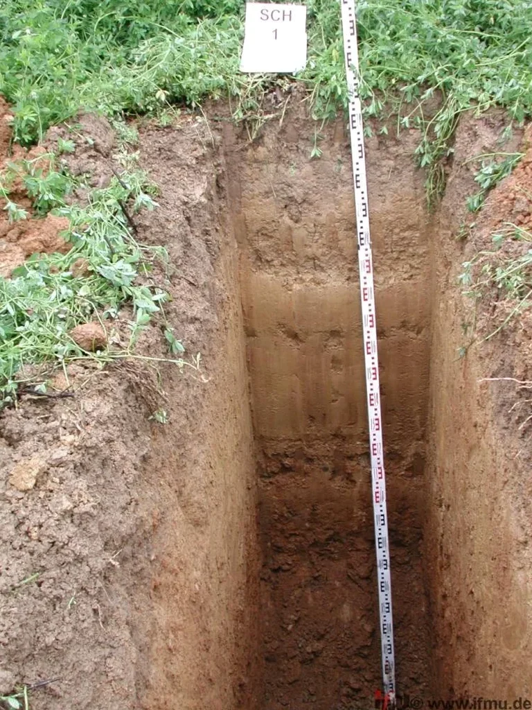
The National Building Code of Canada (NBCC 2020) and CSA A23.3 place explicit emphasis on direct subsurface observation when designing foundations in glaciolacustrine plains—and Regina sits squarely on one. The city’s subgrade is dominated by up to 15 metres of heavily overconsolidated glacial Lake Regina clay, interbedded with silt and sand lenses deposited during the Wisconsinan glaciation. Borehole data gives you a profile; an exploratory test pit gives you the face. At depths typically ranging from 3.0 to 5.5 metres, these excavations allow our geotechnical team to log stratigraphic contacts, measure jointing and fissuring in the clay till, extract undisturbed block samples, and conduct direct plate-bearing or pocket penetrometer tests on the exposed surface. For projects in the Wascana Creek floodplain or near the evaporite-rich Bearpaw Formation subcrop, the visual continuity provided by a test pit is irreplaceable—particularly when verifying the competence of a bearing stratum before committing to a footing design that relies on presumed undrained shear strength values.
An exploratory test pit transforms a one-dimensional borehole log into a three-dimensional understanding of Regina’s complex glacial stratigraphy.
Methodology and scope
Regina’s subsurface is not a uniform clay mass. The glacial Lake Regina sequence contains intermittent tills, outwash sands, and in some east-end neighbourhoods, swelling clays derived from Cretaceous shale weathering. An exploratory test pit in Regina exposes these transitions in situ: you can trace a sand lens laterally, measure its dip, and observe groundwater seepage at the interface—something a split-spoon sample simply cannot capture. Our field crews operate hydraulic excavators with smooth-edged buckets to preserve face integrity, and we follow the Saskatchewan Occupational Health and Safety regulations for trench safety, including sloped walls or trench boxes per ground conditions. In-situ density testing using the sand cone method can be performed directly on the pit floor, while hand-cut block samples are wrapped in wax and transported to our laboratory for consolidated-undrained triaxial testing. Where the water table—commonly at 1.8 to 2.5 metres depth in spring—intersects the excavation, we stage dewatering pumps and log the inflow rate as a direct measure of the mass hydraulic conductivity, feeding into the groundwater control plan for subsequent deep excavations.
Local geotechnical context
The same high-plasticity clay that gives Regina excellent bearing capacity when dry becomes a safety and stability concern during pit excavation. Spring melt and summer convective storms can saturate the upper 2 metres rapidly, reducing the undrained shear strength of the Battleford Till and overlying lacustrine clay by 30 to 50 percent within hours of exposure. An open test pit left unsupported in these conditions risks sloughing or base heave, particularly where artesian pressures build in sand lenses confined by the overlying clay. Our approach in Regina incorporates real-time stability assessment: if the excavation face stands unsupported for two hours without spalling, we proceed with logging and sampling; if not, we install hydraulic shores or cut the walls back to a 1.5:1 slope. Dewatering discharge is managed to avoid reintroducing water into the active pit, and all excavations are backfilled the same day with moisture-conditioned native soil compacted in 200 mm lifts to match the surrounding in-situ density.
Applicable standards
NBCC 2020 – Division B, Part 4 (Structural Design) references to site investigation requirements, CSA A23.3 – Design of Concrete Structures, clauses on foundation subgrade evaluation, ASTM D4220 – Standard Practices for Preserving and Transporting Soil Samples, Saskatchewan OH&S Regulations – Trenching and excavation safety provisions, ASTM D1556 – Standard Test Method for Density of Soil in Place by the Sand-Cone Method
Common questions
At what depth does an exploratory test pit become impractical in Regina compared to drilling?
In Regina’s lacustrine clay, test pits are generally practical to a depth of 5.5 metres with conventional hydraulic excavators. Beyond that, the combination of high lateral earth pressures in the overconsolidated clay and the proximity of the water table—often at 2.0 to 2.5 metres—makes open-cut excavation increasingly difficult to keep dry and stable. For stratigraphic verification below 5.5 metres, we typically transition to a solid-stem auger drilling program, using the test pit data from the upper 5 metres to calibrate the borehole log.
What is the typical cost range for an exploratory test pit investigation in Regina?
An exploratory test pit in Regina, including mobilization of a hydraulic excavator, up to 5.5 metres of excavation, stratigraphic logging, in-situ density testing, collection of undisturbed block samples, and same-day engineered backfill with compaction testing, typically ranges from CA$710 to CA$1,310 per pit. The final cost depends on access constraints, groundwater conditions requiring dewatering, and the number of samples extracted for laboratory analysis.
How do you ensure trench safety during a test pit excavation in the heavy Regina clays?
Safety during exploratory test pit operations in Regina follows the Saskatchewan Occupational Health and Safety trenching provisions. In the stiff, overconsolidated glacial clay that dominates the city’s subsurface, short-term vertical cuts up to 3.0 metres can often stand unsupported, but we continuously assess face stability. Where the clay becomes fissured, softened by groundwater, or where sand lenses are present, we slope the walls back to a minimum 1.5:1 ratio or install a certified trench box. All personnel remain outside the excavation unless the walls are protected, and a spotter monitors the pit continuously during logging and sampling.